GLOSA
Optimal speed advice for going green
GLOSA (Green Light Optimal Speed Advisory) is an innovative service that advises drivers of the optimal speed to adopt in order to reduce stopping times at traffic lights. It works simply: GLOSA alerts drivers of the presence of an intersection with traffic lights when they are approximately 500 meters away. The application provides advance information on the number of lanes affected, the possible directions for each, and the status of the traffic light.
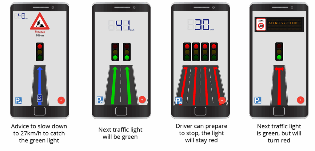
In addition, the application uses the traffic light countdown and the user’s speed to predict the colour of the traffic light when the vehicle arrives. Based on this prediction, the application advises the driver to either:
Continue at the current speed because the light will be green -> there is no point in accelerating
Stop and/or turn off the engine because the light will be red for a long time -> save energy
Slow down because the light is red but will turn green -> improve traffic flow, reduce the number of stops and starts
In Bordeaux, the GLOSA service is available on your Android or iOS smartphone via the CTD – Mobilité connectée application. It is intuitive and ergonomic, developed and installed by our teams. Before taking the wheel, simply launch the application, which will geolocate you throughout your journey. It will advise you on the optimal speed to adopt. Your journey will then be smoother, safer, and less energy-consuming.
Download CTD – Mobilité now !
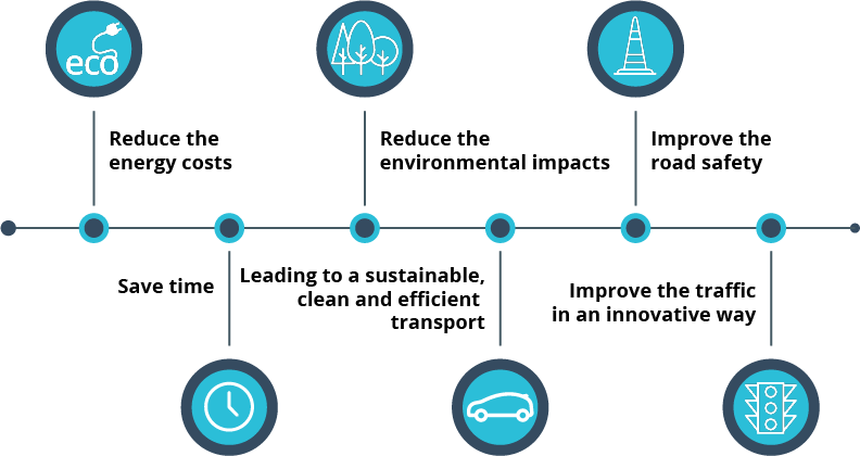
The objectives of this service
The different steps of deploying the GLOSA solution
Two standardised data sources are essential for the proper functioning of the GLOSA solution:
- Intersection Mapping (MAP) : This data allows the GLOSA application to determine when the driver is approaching an intersection. To know in particular which lane(s) they are likely to take. NeoGLS creates the map from data provided by the city administration, transcribing them into a proprietary data entry tool. This data includes the identifiers of all traffic lights, the speed limit of the traffic lanes, and the possible direction (turn left, turn right, or continue straight).
- Traffic Light Status (SPAT) : This data allows the application to determine the colour and duration of the current traffic light phase. For example, the light is red for 14 seconds. Accessing this data allows the application to calculate the optimal speed recommendation.
There are two different ways to retrieve traffic light status data (SPAT): by communicating directly with the local traffic light controller or by communicating with a centralised traffic light management system. Both devices transmit traffic light status data. Depending on their login name, either to the RSU (Road Side Unit), directly to the application, or via a hybrid solution combining these two transmission modes.
We offer three different implementation solutions
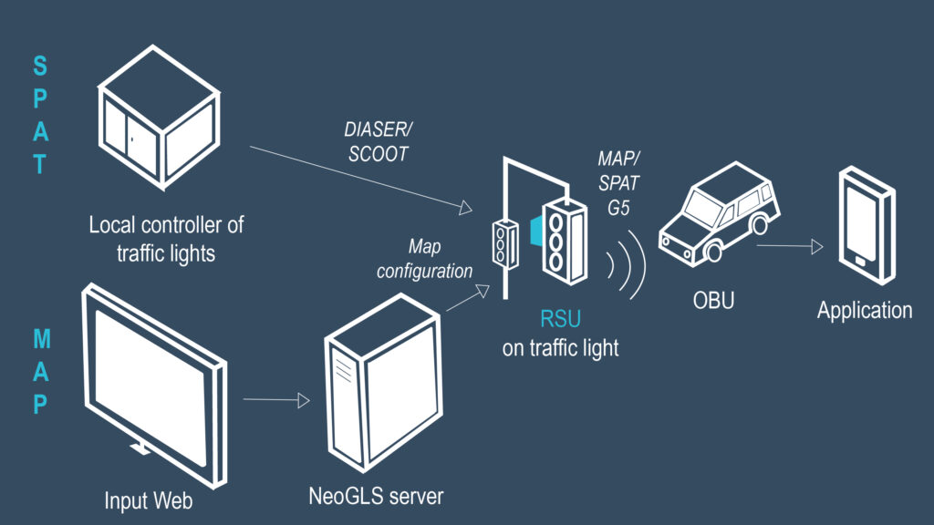
Solution 1
- NeoGLS enters the MAP into the ITS server using the web interface.
- The latter sends the MAP to the RSU, located at an existing intersection. The RSU also receives data from the local traffic light controller regarding the current status of the lights (color and duration) in the traffic light controller’s language (e.g., DIASER : Standard Dialogue for Equipment Control).
- The RSU broadcasts the information (SPAT + MAP) via V2X.
- The OBU (On Board Unit) receives this data and transmits it to the on-board application.
- The application performs the calculations and then provides the user with advice.
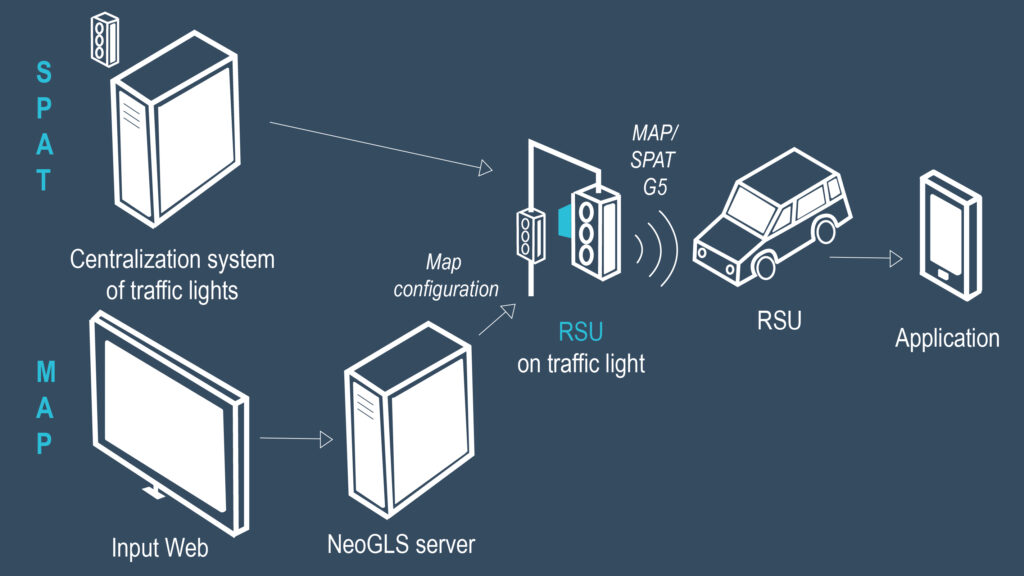
Solution 2
- NeoGLS enters the MAP into the ITS server using the web interface.
- The latter sends the MAP to the RSU, located at an existing intersection. The RSU also receives data from the centralised traffic light system regarding the current status of the traffic lights (colour and duration) in the traffic light controller’s language (e.g., DIASER).
- The RSU broadcasts the information (SPAT + MAP) via V2X.
- The OBU receives this data and transmits it to the onboard application.
- The application performs the calculations and then advises the user.
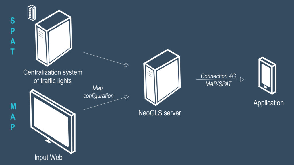
Solution 3
- NeoGLS enters the MAP into the ITS server using the web interface.
- The latter receives data from the centralised traffic light system regarding the current status of the traffic lights in the traffic light controller’s language (e.g., DIASER).
- The server transmits this information directly to the on-board application via a 4G connection.
- The application performs the calculations and then provides the user with advice.